


Location
Latitude 38° 01’ 2’’ N Longitude 22° 45’ E
PORT DESCRIPTION
Pilot & Tug boat can be arranged at normal daytime hours.
Port Situation at Kiato
Berth is possible only during daytime & departure is available during daytime and/or nighttime.
There are no specific data/directions concerning seasonal congestion.
There are no special instructions concerning navigation at the Port area, during wintertime.
Normal Working Hours
08.00 - 12.00 hrs & 13.00 - 17.00 hrs (From Monday until Friday) - One Shift.
Restrictions
Terminal Port Restrictions:
Dock No 1: Depth 5,00m S.W. - Length 120m
It is NOT allowed in this dock to disch and/or load cargo of Methanol.
Dock No 2: Depth from 5,80m up to 13,20m S.W. - Length 190m (However please note that at this dock, vessels with loa over 135 m CAN NOT be accommodated due to maneuvering restrictions)
Only in this dock is allowed to disch and/or load cargo of Methanol.
There are no restrictions concerning beam & air draft.

Location
UNLocode GRJKH
Latitude 38° 22’ N Longitude 26° 8’ E
Max Draft 7.5 Time Zone GMT +2
WorldScale No
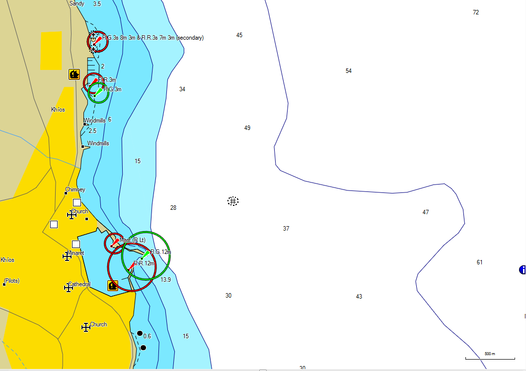
The port of Chios (Khios) is located on Chios Island in the Aegean Sea.
PORT DESCRIPTION
General overview
Chios is the principle port for Nisos Khios and comprises an outer anchorage and an artificial harbor for the ferries and small general cargo vessels. Chios Power Station has an oil berth nearby.
Traffic figures: Aprrox 104,500t of cargos, 2,830 vessels and 502,500 passengers handled annually.
Load line zone: Summer.
Max size: Draught 7.5m.
NAVIGATION
Anchorages
Outer anchorage: The anchorage off Chios extends from 0.5nm S to 2nm N the harbor entrance. For a distance of approx 4nm N of the harbor entrance, the coast is fringed by a narrow bank, but the bottom falls away steeply and at the distance of approx 0.3nm from the shore the depths are considerable. The recommended anchorage is approx 1nm NE of the citadel, in depths of 22.0-33m, mud. It is possible to anchor nearer the harbor, but here the bottom consists of soft mud and the holding is not so good.
A submarine outfall pipe marked at its extremity by a litghbuoy (special) extends approx 1,000m NE from a position 1.25nm S of the harbor entrance.
Tidal range flow: Range approx 0.3m.
Dock density: 1025.
Charts: BA 1625. Admiralty Pilot NP48, NP286 (3).
ABOUT ELEFSIS SHIPPING AGENCY
OUR MISSION
WHAT WE AIM FOR
Committed to provide the highest levels of agency services, to increase transparency in the disbursement account process, create operational efficiency and improve the price –value relationship for both principals of shipping companies.
OUR VISION
WHAT WE NEED TO ACCOMPLISH
Is clear, to be recognized as the leading shipping agency service provider in Greece, one who clearly understands the commercial nature of shipping.
Our hard work, honesty and reliable service, create a strong name in International Shipping, which has served us in good stead over the years that our company has been operational.


Your Ship Agent in Greece


